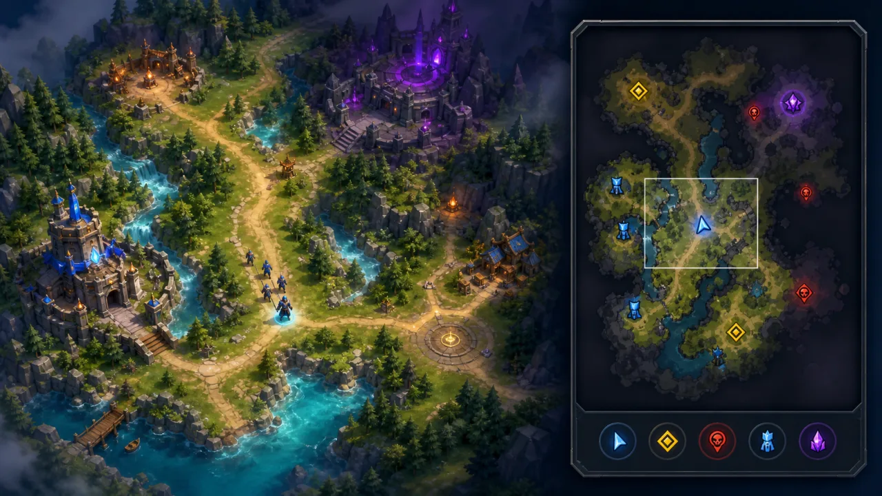
A good minimap turns a large HTML5 game world into an immediate decision tool. It shows where the player is, which direction the camera faces, where objectives and teammates are, and which regions remain unexplored without becoming a second full renderer. The most reliable design separates static terrain, live markers, fog data, and interaction so each layer can update at the frequency it needs.
Define what the minimap communicates
Before writing code, list the information players need during play. Common layers include terrain, walkable paths, water, team structures, the player, allies, visible enemies, objectives, pings, and the camera viewport. Every marker should have a visibility rule and a priority.
A minimap is not an exact miniature of the scene. Remove decorative detail that competes with navigation. High-contrast shapes and consistent symbols are more valuable than tiny trees, particles, or shadows.
Choose map coordinates and bounds
Store a world-space rectangle covering the playable area: minimum X and Y, width, and height. Convert any world point into normalized map coordinates with subtraction and division, then scale those values into minimap pixels. If the minimap’s vertical axis runs opposite the world axis, invert the normalized Y value explicitly.
Clamp markers to the playable bounds. For out-of-bounds objectives, place a directional indicator at the edge instead of allowing icons to disappear or overlap the frame. Keep this transform in one tested utility so every layer uses identical math.
Support rectangular and rotated maps
A north-up minimap is simplest and helps players build a stable mental model. A camera-up minimap rotates with the view and can feel more immediate in action games. If rotation is enabled, rotate markers around the minimap center and keep icon labels upright.
For nonrectangular worlds, use a mask texture to clip oceans, voids, or unreachable margins. The world-to-map transform can remain rectangular while the mask defines the visible silhouette.
Cache the static terrain layer
Render terrain once into an offscreen canvas or WebGL texture. Use flat colors or simplified tiles for ground, walls, roads, and water. Rebuild only when the level changes or a permanent event alters the map.
When the world uses chunked tile data, generate the minimap alongside the pipeline in HTML5 Tilemap Rendering. Each chunk can own a small cached minimap tile. Loading, unloading, or modifying a chunk updates only the matching map region.
Separate dynamic markers
Draw units, objectives, pings, and temporary hazards on a second layer every frame or at a controlled update rate. Marker objects need a world position, icon or shape, color, scale rule, rotation rule, team, priority, and visibility policy.
Reuse marker objects for repeated pings and transient events. If the game already pools projectiles or particles, the same reset discipline from HTML5 Object Pooling applies: clear stale team, visibility, and lifetime state before reuse.
Integrate fog of war
The minimap should respect the same hidden, explored, and visible states as the main world. Sample or downscale the logical visibility grid from HTML5 Fog of War System instead of calculating a second line-of-sight solution.
Hidden terrain can be fully masked, explored terrain can remain darkened, and current visibility can reveal live markers. Enemy icons should disappear or become last-known-position markers according to game rules. Client-side fog is a presentation feature, not a security boundary for competitive multiplayer.
Draw the player and camera viewport
The player marker should remain unmistakable at every scale. A simple arrow or high-contrast ring communicates position and facing. Clamp its minimum on-screen size so zooming out does not make it vanish.
Convert the camera’s world-space corners into minimap coordinates and draw a rectangle or polygon over the map. This shows which region is currently on screen and makes click-to-pan behavior predictable. For rotated or perspective cameras, project the visible ground-plane corners rather than assuming an axis-aligned rectangle.
Handle marker density
Dozens of units can overlap at minimap scale. Cluster low-priority markers by cell, show a count or stronger aggregate symbol, and keep the player and critical objectives above clusters. Apply small deterministic offsets only when overlapping markers must remain individually selectable.
A spatial hash can gather markers within the minimap or camera area without scanning the whole world. The query structure in HTML5 Spatial Hash Grid is especially useful for large multiplayer or strategy maps.
Set update frequencies by layer
Static terrain updates on map changes. Fog updates when its dirty regions change. Objective markers may update a few times per second. The player and camera frame can update every rendered frame. Assigning separate frequencies prevents a slow layer from forcing unnecessary redraws elsewhere.
Interpolate marker positions visually when logic updates less frequently than rendering. Keep gameplay authority on the fixed simulation step described in HTML5 Fixed Timestep Game Loop.
Use dirty rectangles
If only a few icons move, clear and redraw their previous and current pixel bounds instead of the entire marker canvas. Expand each dirty rectangle by icon radius and shadow padding, then merge overlapping regions. Full-layer redraws may still be simpler and faster for small minimaps, so measure both approaches.
For fog or destructible terrain, map dirty world chunks directly to minimap pixel rectangles. This avoids uploading a full texture when one door or terrain patch changes.
Add interaction carefully
Click-to-pan converts a pointer position from minimap pixels back into normalized coordinates and then world coordinates. Clamp the target to the playable area and move the camera smoothly. Touch devices need a large hit region and should distinguish a tap from a drag.
Prevent minimap input from leaking into world controls. Capture the pointer for dragging, stop the game action beneath the interface, and provide keyboard or controller alternatives when navigation is important.
Design markers for readability
Use shape as well as color: triangles for players, diamonds for objectives, circles for neutral points, and outlined symbols for warnings. Add a subtle background plate or border so the minimap stays legible over bright and dark game scenes.
Do not rely on red versus green alone. Test palettes and symbols using HTML5 Colorblind-Friendly Modes and preserve essential contrast with HTML5 High-Contrast Settings.
Scale for mobile and high DPI
Size the minimap in CSS pixels for comfortable interaction, then allocate its backing canvas according to device pixel ratio within a sensible cap. Static textures can remain lower resolution than the interface frame. Avoid rebuilding every cached layer after minor viewport changes.
On small screens, offer compact and expanded modes. Keep touch controls away from minimap gestures, respect safe areas, and ensure the close or zoom control has a generous target.
Measure the real cost
Track terrain cache generation, fog upload, marker queries, marker draw time, and final compositing separately. Test crowded scenes, map reveals, resizing, and rapid camera movement. Use the percentiles and budgets in HTML5 Frame-Time Telemetry to decide whether clustering or dirty rectangles are worth their complexity.
Debug visually
Add overlays for world bounds, normalized coordinates, chunk borders, marker priority, fog state, camera corners, and dirty rectangles. A click debug mode can print the round-trip conversion from minimap pixel to world point and back. Small transform errors become obvious before they reach production.
Implementation checklist
- Centralize world-to-minimap and minimap-to-world transforms.
- Cache static terrain separately from live markers.
- Reuse the authoritative fog visibility grid.
- Draw the player and camera viewport at stable minimum sizes.
- Cluster low-priority markers when density rises.
- Update each layer only as often as required.
- Support pointer, touch, keyboard, and controller navigation.
- Measure layer costs on high-DPI mobile devices.
A performant minimap is a layered data visualization, not a second camera. Cache what rarely changes, update live information with simple transforms, and let gameplay visibility decide what players may know. This architecture keeps navigation clear while protecting the frame budget of large HTML5 worlds.